
In the morning we went to the Lab early to see the data that had been crunching overnight creating a beautifully intricate point cloud in Photoscan which had a huge number points making it very detailed and also having an accuracy of ~5cm.
We went to a trimble workshop after this to see the how the post processing of the Imaging rover took place as this where a majority of our time will be spent as their new system minimises the need for extensive field time as GPS points and a 360 degree panorama can be captured in a matter of seconds using the Trimble V10 Imagining Rover.
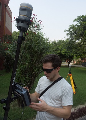
We then used our own Trimble V10 Imagining Rover with the Trimble R10 GNSS receiver and using another receiver as a base station. The Trimble guys helped us to calibrate the kit and we played around with it to get familiar and practice with the kit to minimise the amount of time we would need in the field. We also discussed fine technical points with the Trimble representatives on how one of the GBNIR cameras in the UX5 worked and how to extract the bands the actual IR Photos. We also worked out how to connect the Rover to a remote base station meaning using the mobile network meaning that it wouldn’t be strictly necessary to take one with us to the field which would eliminate the error of having to re set up the base station when flying on separate days (and save us having to carry another piece of kit!)
In the evening went for dinner with the Earth Sciences Faculty staff which was really nice and got to meet some interesting people who all have their own varying research projects focusing on different subjects but mainly concerning the Ganges. Having never formerly being a spice lover I am slowly getting use the heat on the food here but still getting through a liter of water a meal in an attempt to subdue the fire.